Virtual Tours
Take a tour on your own—either in the cemetery with this page up on your mobile device or from your own space wherever you are! We look forward to seeing you inside the gates soon, but if you can’t be there, we hope this virtual tour gives you a good idea of what it's like to visit this incredible historic landscape.
Eastern Cemetery in 12 Stops
Though countless hours can be spent exploring the historic landscape, this tour is designed to allow you to see some of its highlights in under an hour. The self-guided tour is designed as a loop walk, running somewhat counter-clockwise from the front gate at Congress Street.
Watch your step as you walk through the stones. Sunken spots, iron posts, small markers are all tripping hazards! Also, please never step backwards unless you double-check what you're stepping on first.
List of Stops
This list of links will help you skip down the page.
- Introduction
- Stop 1: Dead House, City Tomb
- Stop 2: Alden Monument
- Stop 3: Pine Tree, Commemorative Boulder, Mary Green, Samuel Moodey
- Stop 4: Stephen Larrabee
- Stop 5: Proctor Children, Great Fire
- Stop 6: Stephen and Tabitha Longfellow
- Stop 7: Tombs of Captain Burrows, Captain Blyth, Lt. Waters (War of 1812)
- Stop 8: Wadsworth Monument, Adams Children
- Stop 9: African American Ground Overlook
- Stop 10: Quaker Ground
- Stop 11: Preble Monument, Field of Tombs
- Stop 12: Alonzo Stinson Monument, Strangers Ground
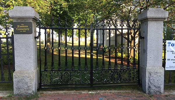
Eastern Cemetery Gates on Congress Street (full-size image of the gates on Flickr)![]()
Introduction
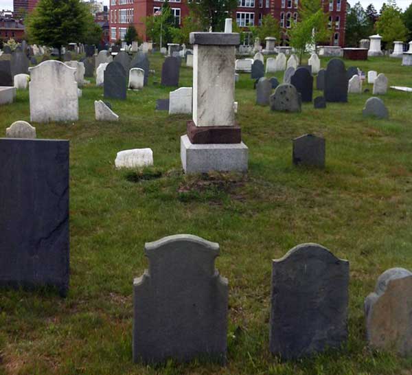
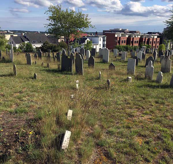
Welcome to the Eastern Cemetery, one of the oldest and best examples of colonial burying grounds in New England. Established in 1668, it was active for over 200 years and held the remains of more than 7,000. Today, about 3,000 gravestones survive in its 6 acres. The cemetery is on the National Register of Historic Places and is designated by the City of Portland as an historic cemetery.
Today, the Eastern Cemetery offers a wonderful variety of gravestones memorializing the Portland area's residents—famous, infamous, rich, and poor. Special sections were set aside for Quakers, African-Americans, and Catholics.
We hope you enjoy this guide through Portland’s oldest historic site!
Directions: From Congress Street, enter through the iron gates, and stop at the little white tool shed. You have reached Stop 1, the Dead House.
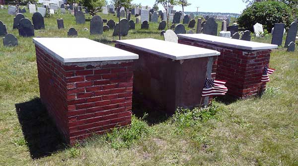
Stop 1: Dead House, City Tomb
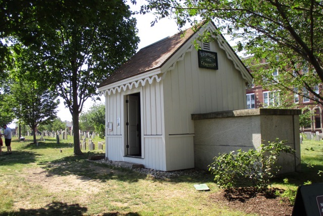
Dead House and city tomb (by Ron Romano)
In many New England colonial cemeteries, in the winter, bodies of those who died were stored in a “dead house” until spring thaw allowed for digging. The Eastern Cemetery's Dead House, now used as a tool shed, was built in 1873 and is not the first. This area of the cemetery was private property until 1795, so earlier dead houses would have been found in the older (back) section of the cemetery. The granite box attached to the right of the Dead House covers the stairway down into the City Tomb, which was constructed in 1849 and used for about 50 winters to hold the coffins of Portland’s dead until spring.
Later read: Renovation of the Dead House
Side note: If you’re looking at the door of the Dead House, turn around, and you’ll see a boulder with a plaque on it—you’ll come back to it at the end of your loop tour.
Directions: Walk to the flagpole along the path known as Funeral Lane. As you approach the flagpole, look right to find a very tall pink granite monument. You have reached Stop 2, the Alden monument.
Side notes: The land, from Congress Street to the flagpole, was originally the private field of Portland’s first minister, Reverend Thomas Smith (1702–1795) and is considered the new part of the cemetery. It was deeded to the town upon Smith's death and provided much-needed burial space since the original part of the cemetery was near capacity. Note the large brick building. Originally the North School, it was built 1867, and has been converted into apartments.
Stop 2: Alden Monument
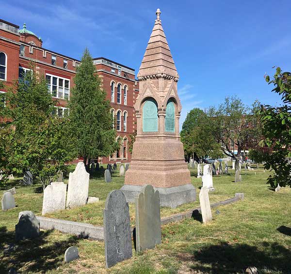
Alden monument with North School in the background (full-size image of the Alden monument on Flickr)![]()
The monument for Rear Admiral James Alden, Jr., towers over all others. He was a Portland native (born 1810) and direct descendent of the Mayflower’s first passengers John Alden and Priscilla Mullins. He sailed the world during his life-long naval career, explored the South Pacific, and discovered Antarctica. He circumnavigated the globe on the USS Constitution and served in the Civil War. Though he died in San Francisco in 1877, his body was returned home to Portland for burial. He rests in a family lot that holds his parents, wife, and siblings.
Side notes: Alden’s monument was machine-made in the late 1800s, but the majority of stones that surround it are far more typical of those found in a colonial cemetery. Notice the slate (gray) and marble (white) stones that decorate the vast majority of graves at Eastern Cemetery. These stones were hand-carved by stonecutters and marble workers who were active from the 1700s to the middle of the 1800s—before granite and machines replaced them.
Later read: Subterranean Celebrity - James Alden (August 2008 eNews)
Directions: From the Alden monument, turn away from Congress Street to the back of the cemetery. Carefully walk through the stones to the pine tree that has a large granite box tomb in front of it and a boulder with a plaque next to it. This is the oldest part of the cemetery. You have reached Stop 3.
Stop 3: Pine Tree, Commemorative Boulder, Mary Green, Samuel Moodey
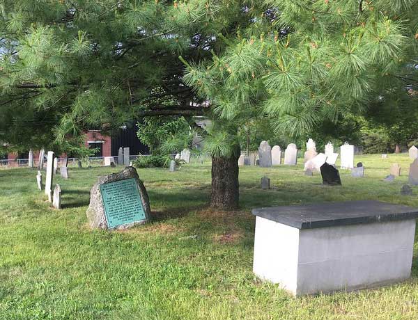
War of 1812 boulder and Smith box tomb under the pine tree (full-size image of the trio on Flickr)![]()
The pine tree shades a commemorative War of 1812 boulder and the box tomb for Reverend Thomas Smith and his family. There once was a huge pine tree on this spot that mariners used to confirm the location of the Portland waterfront as they sailed into Portland harbor. It blew down in a hurricane in 1815, and has been replaced a few times more over the years.
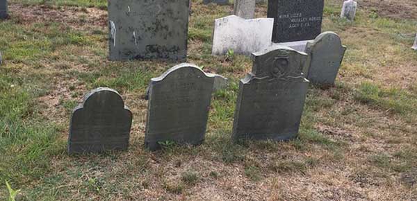
Directions: After you read the plaque on the boulder, look to your left and you’ll see the back (uncarved) sides of 2 slate markers. Step around to the front of them, so you can read their inscriptions.
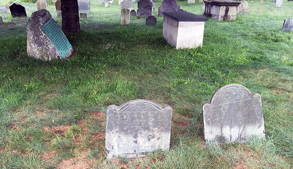
Mary Green and Samuel Moodey markers (full-size image of the Green and Moodey markers on Flickr)![]()
The marker on the left is for Mary Green who died in 1717. Though she was not the first buried in the cemetery, her stone is carved with the oldest death date. To the right, is the 1729 marker for Major Samuel Moodey, who resettled Portland in 1713, after conflicts with native Americans had left the town without English settlers for 20 years. Moodey was married to Mary Green’s sister, Esther. Note the similarity in carving between the 2 markers: a fancy border and a "death's head" or winged skull.
Later read: The Moodys at Eastern Cemetery—a paper by Ron Romano
Directions: Turn away from the Green and Moodey markers, and walk a few paces in parallel with the fence line for 2 rows. Look to your right for a small slate marker near the leafy tree. You have reached Stop 4, the Stephen Larrabee marker.
Stop 4: Stephen Larrabee
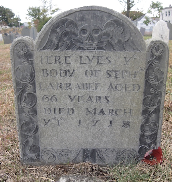
Stephen Larrabee marker (by Ron Romano)
Stephen Larrabee's marker (described by gravestone experts as "wonderful") is carved with the second-oldest death date in the cemetery—1718. Like the Green and Moodey markers, this slate was imported from Boston, since Portland did not have its own stonecutter until 1800. The skull of the death’s head symbolizes Mr. Larrabee’s mortal remains while the wings represent the flight of his soul to heaven. Look carefully at the bottom center border, and you’ll find an hourglass representing of the end of life. Notice the old English spelling of “lyes” instead of “lies” and “ye” instead of “the.”
Later read: Spirits Alive has a new logo (April 2015 eNews)
Directions: From the Larrabee marker, look to your right, and walk down about 10 steps to a deteriorated wide but low gray (slate) stone. You have reached Stop 5, the Proctor marker.
Stop 5: Proctor Children, Great Fire
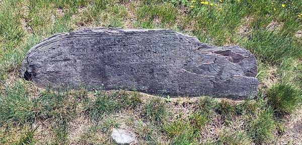
Proctor marker (full-size image of the Proctor marker on Flickr)![]()
John Proctor was the first man hanged for witchcraft in Salem, Massachusetts, in 1692. His grandson Samuel moved to Portland, and 3 of Samuel’s children are memorialized on this marker. Sary, Thomas, and Richard Proctor died between 1741 and 1748, all under age 10. This marker is easy to miss, so look closely to see the inscribed names and dates for these children of a famous great-grandfather.
Side note: When you’re finished reading the inscriptions on the Proctor stone, look up and forward all the way to the far corner of the cemetery. That is the patch of land set aside for burial of Portland’s African-Americans. While the majority white Protestant residents claimed the burial plots closest to the entrances to the burying ground, people of color and of different religions were segregated to the far back corners of the cemetery. We will visit the African-American patch later in the tour.
Now, look to your right and find the chain link fence that runs along the back edge of the cemetery. The imposing stone wall upon which the fence sits was built after Portland’s great fire of 1866, which destroyed almost all of the buildings in this area. You are looking at what once was the front of the burying ground—everyone entered along this edge which had a gentle slope down into town. After the great fire, the town carved away the hillside and front border of the cemetery (along with the cemetery entrances) in order to extend Federal Street. The retaining wall was built, the fence was put up, and access from this side was completely eliminated. The orientation of the cemetery completely flipped from front to back, and the front entrance became the Congress Street gate where you entered.
Directions: From the Proctor marker, turn left. Carefully walk through the stones past a deteriorated brownstone monument and a recently-repaired box tomb. From there, turn right, and walk ahead until you see 2 tall illegible marble markers. Take a sharp left there. You have reached Stop 6, the Longfellow markers.
Stop 6: Stephen and Tabitha Longfellow
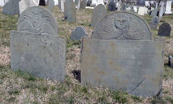
Stephen and Tabitha Longfellow markers (full-size image of the Longfellow markers on Flickr)![]()
Stephen (died 1790) and Tabitha (died 1777) Longfellow, great-grandparents of world-famous poet and Portland native, Henry Wadsworth Longfellow (1807–1882) are buried here. Their slate markers, hand-carved in Boston, are decorated with winged faces—gentler imagery than the winged skulls we’ve just seen. Also called “soul effigies,” the face has wings that assist the soul on its journey to heaven. Note the other interesting designs on the stones for other family members to either side of Stephen and Tabitha.
Side note: Nearly all of the markers around you are oriented in the same direction. As you look to the east (Mountfort Street), you can see the inscriptions on the front side of these markers. If you turn around to the west (North School), you’ll be looking at the back of the markers. This is because people were buried in an east-west direction, with their heads to the west and feet to the east, so that their souls could rise (resurrect) to greet the dawn. Also note that most graves are decorated with a pair of markers—the inscribed and decorated headstones are often paired with a much smaller footstone that often only include initials and dates. These indicate the borders of the plot. The inscribed sides face away from the middle to allow visitors to read who was buried there without stepping on the grave itself.
Later read: Subterranean Celebrity – Stephen Longfellow (April 2010 eNews)
Directions: From the Longfellow markers, turn left, and walk back up to Funeral Lane. When you get to the lane, turn right, and walk toward the iron gates on Mountfort Street until you see 3 brick box tombs on your right. You have reached Stop 7, the captains' tombs.
Side note: Funeral Lane has taken a 90-degree turn at the flagpole and acts as the border between the old (right—individual slate and marble markers) and the new (left—large monuments in even rows) sections.
Stop 7: Tombs of Captain Burrows, Captain Blyth, Lieutenant Waters
Burrows, Blyth, Waters box tombs (full-size image of the tombs on Flickr)![]()
Perhaps the most famous men buried at Eastern Cemetery are US Captain William Burrows and British Captain Samuel Blyth. Both young men died on September 5, 1813, in the battle between the HMS Boxer and USS Enterprise just north of Portland. As France and Britain were fighting for world domination, the young nation of the United States was caught in the middle. Captain Blyth had positioned the Boxer to block US access to Canada for trade. Captain Burrows sailed the Enterprise to clear the way. The battle did not last long—Blyth was killed very quickly, while Burrows suffered a few hours with a mortal wound—long enough to learn that they had won the battle. The captains were buried side-by-side, and were joined by the Enterprise's Lieutenant Kervin Waters in 1815. The 3 brick box tombs—like all other box tombs at Eastern Cemetery—do not hold the remains of the deceased; they were buried underground and topped with the box tombs as monuments.
Side notes: These box tombs are only 3 of the more than 200 markers for veterans in the Eastern Cemetery. Decorated with private or government-issued markers, veterans here served in conflicts from the Revolutionary War to the Civil War.
Later reads:
- The Captains of the Boxer and the Enterprise
- Military Markers in Eastern Cemetery
Directions: Immediately beside (south) of the Waters tomb is a tall pedestal monument made of granite, marble, and sandstone. You have reached Stop 8, the Wadsworth monument.
Stop 8: Wadsworth Monument, Adams Children
Wadsworth monument, Adams markers in foreground (full-size image of the Wadsworth monument on Flickr)![]()
Henry Wadsworth (uncle of the poet) died in Tripoli in 1804. His body was never returned to his homeland, so this monument, a cenotaph—meaning the marker memorializes someone who is buried elsewhere—was erected by his family in his honor. This impressive monument serves as an example of the conservation efforts of Spirits Alive. At some point, it had been toppled, and in 2013, Spirits Alive had it put back together. More than 500 gravestones and monuments have received the careful attention of Spirits Alive’s trained volunteer conservation crew.
Adams children's markers (full-size image of the Adams markers on Flickr)![]()
Directions: From the Wadsworth monument, turn toward Funeral Lane and look right. In the next row, there are 3 small slate markers. These are carved by Portland’s first stonecutter, Bartlett Adams, for 3 of his children: Eliza, George, and Bartlett Jr.
Until Bartlett Adams arrived in Portland in 1800, families wanting finished gravestones would need to make the 100-mile sea voyage to Boston to have them made in one of the many stone shops there. With Bartlett Adams’ arrival, all that changed, and people could visit Adams’ shop near the cemetery to have stones carved for their loved ones. Adams and the men who worked for him created about 700 of the gravestones found in Eastern Cemetery today. He and his wife Charlotte Neal had 7 children, but 6 of them predeceased him. Bartlett Adams died in 1828, at the age of 51. His shop produced hundreds of gravestones that can be found in early cemeteries throughout southern Maine.
Note the extraordinary effort Bartlett Adams put into the marker for his namesake son, who died in 1806, at just a few months old. This is one of his greatest works, showing his amazing talent as a carver of stone and his expertise in lettering and numbering.
Later reads:
- Wadsworth Monument Repair
- Early Gravestones in Southern Maine – The Genius of Bartlett Adams (book by Ron Romano)
Directions: As you read the Adams markers, look to your right. Carefully make your way diagonally through the stones towards the back corner of the cemetery, until you reach the crest of the hill. You have reached Stop 9, the African American Ground Overlook.
Stop 9: African American Ground Overlook
View of African American ground (by Ron Romano)
Black people have a rich history in Portland even though records predominately present it through White perspectives. Though many in the earliest Black population were likely enslaved and African, a thriving neighborhood of free Black people lived near this corner of the cemetery. The Abyssinian Meeting House, the first Black church in Maine and third oldest in the United States, was built in 1829, and is just across the street from the back of the cemetery. Burial records were not well-maintained for Black people, and many of their graves were left unmarked. We know that hundreds were buried here, for in the 1820s, a second ground was designated since this section was full. We’ll visit that ground later in this tour.
Later read: The Abyssinian Restoration Project in Portland, Maine (website)
Directions: From the crest of the hill, turn back towards Funeral Lane. There’s a narrow grassy path that leads you back. About at the halfway point to Funeral Lane, pause, and look to your left for an area of small round-top marble markers set at a diagonal to the other stones in the cemetery. You have reached Stop 10, the Quaker Ground.
Stop 10: Quaker Ground
Part of the Quaker ground (full-size image of the Quaker view on Flickr)![]()
In 1795, when the town received all of Reverend Smith’s field, burial rules were established and improved record-keeping efforts began. Also, a designated burial ground for the town’s Quakers (members of the Society of Friends) was established. Quakers lived an austere life, and for many years were buried only in unmarked graves. In the early 1800s, Quakers made changes to allow graves to be marked with very simple, undecorated gravestones. The few marble markers you find here are the types of stones that were allowed on Quaker graves. Though there are just a few dozen records of Quaker burials, there are certainly many more people buried here than we’ll ever know.
Directions: Take a few more steps back to Funeral Lane, and cross over it to enter the field of underground tombs. Notice 4 rows of large monuments parallel to Funeral Lane. Look here for the largest marble monument in this section inscribed with the name Preble. This is bordering Funeral Lane. You have reached Stop 11, Preble Monument and the field of tombs.
Stop 11: Preble Monument, Field of Tombs
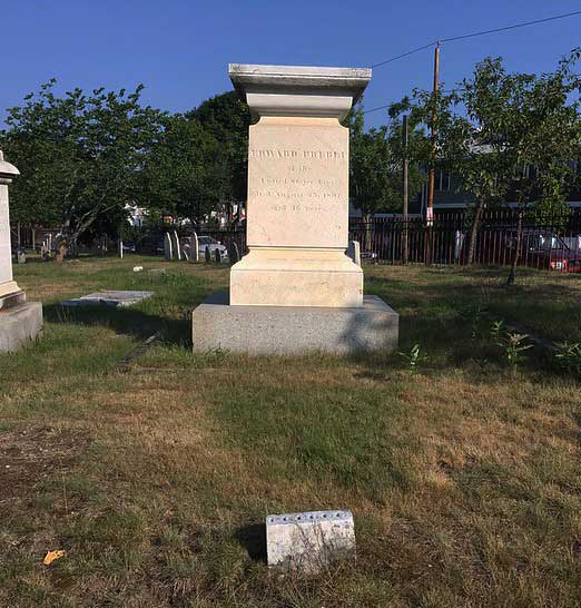
Preble monument (full-size image of the Preble monument on Flickr)![]()
Commodore Edward Preble (1761–1807) was commander of “Old Ironsides," or the USS Constitution. His storied naval career led to a Congressional Medal and an invitation in 1806 to join the cabinet of President Thomas Jefferson. He declined the position due to ailing health and died the next year of consumption at the age of 46.
Preble's tomb is one of 86 located in the 4-row field of tombs. Dug parallel to Funeral Lane, these underground rooms, each with a private entrance, were constructed for Portland’s well-to-do between 1795 to about 1825. Each tomb could hold up to 30 coffins and was decorated however its owners preferred. While many are topped with various monuments such as box tombs (15), ledgers (15), and obelisks (7), 15 are no longer marked at all. Step to the second row in from the Lane and you’ll see the coping stones or curb stones (21) for some tombs. The narrower curbed section denotes the boundary for the private stairway down into the tomb while the larger attached curbed section is the boundary of the tomb itself.
Later reads:
- The Tombs: A 2017 Update to the 1978 “Record of Interments” with New Historical Notes (paper by Ron Romano)
- Underground Tombs of Section A in Eastern Cemetery
Directions: Turn to the front corner of the cemetery where Congress and Mountfort Streets meet. Walk to the large monument. You have reached Stop 12 (the last), Alonzo Stinson Monument.
Stop 12: Alonzo Stinson Monument, Strangers Ground
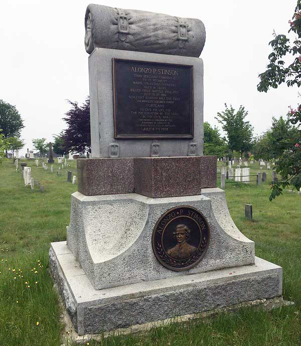
Alonso Stinson monument (full-size image of the Stinson monument on Flickr)![]()
Alonzo Stinson (1842–1861) was the first Portland area citizen to die in the Civil War. He and his brother Harry fought at Bull Run, Virginia. Alonzo died and was buried there—one of 800 lost in that conflict. Harry was among the 1,300 taken prisoner and spent a year in lock-up. In 1908, the city of Portland decided to erect a monument to honor Stinson and other Civil War veterans. The site had become a prime location for visibility with the entrance now on Congress Street. Unfortunately, this ground was occupied—around 1825, as the second designated ground set aside for Black people. Sadly, it is supposed that any remains in this area must have been moved to another part of the cemetery to make way for the impressive Stinson monument.
Side note: On the Congress Street sidewalk, near the Stinson monument, there is a Portland Freedom Trail marker that lists the Portland abolitionists buried here—many who are Black.
Directions: Make your way back to the front gate and stop at the boulder that we noted at the beginning of the tour.
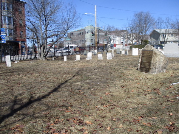
View of strangers ground (by Ron Romano)
For many years, this area—lacking in gravestones—was the site of one of several “Strangers Grounds” at Eastern Cemetery. Also sometimes known as paupers’ fields, these areas were set aside to bury the penniless, friendless, visitors, and unknown people who died in the city. At one time, there was a hearse house in this area. This is where the horse-drawn carriage used to receive the deceased and transport bodies back to the cemetery was stored.
Later reads:
- Subterranean Celebrity: The Strangers (March 2010 eNews)
- How Many People Are Buried Here? (paper by Ron Romano)
CONGRATULATIONS! You’ve made it. We hope you have enjoyed your self-guided tour through historic Eastern Cemetery!